Ashika Morasiewicz
Outdoor Adventurer from the North Shore, BC
Hike to Illal Meadows & Peak – September Long Weekend

September 4-5, 2015
It’s good to be back in the BC mountains!!
After considering a few factors: over 1.5 months of no hiking (for me) and currently fighting off a cold (me again), Ryan and I decided to ease back into the mountains by going for a mellow backpacking trip this September long weekend.
Our original plan was to spend 3-4 days in the Shulaps range, but with the recent storm, which brought a cumulative 50cm of snow in the alpine and well below treeline, we thought ‘heck, no’. We tried to beat the odds of snow by studying Spotwx and Snow Forecast and centering on the Coquihalla, which forecasted very little to no snow to this point. More promising, they were showing only a tiny little bit of rain on Friday afternoon (Sept 4). We decided on the Illal meadows area for the sake of no snow… we should have known better.
Our new plan was to hike into the meadows and set up camp, tag Illal peak in the afternoon, hike up Jim Kelly peak the next day, and hike out. Being my first time in the area, I was stoked to check it out.
After a storm blew in on Friday night, our plans changed once again, and we stayed at camp on Friday, summited Illal Peak on Saturday and hiked out the same day.
Day 1: Illal Meadows
Stats
The hike to Illal meadows offers beautiful alpine meadows with views of surrounding peaks & hiking objectives, including: Jim Kelly Peak, Coquihalla Mountain, Illal Peak, and more. The colours in Fall are stunning.
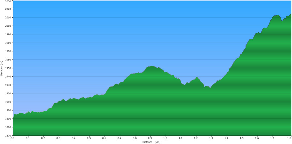
- Elevation gain: 675m (trailhead to tarn at base of Jim Kelly)
- Distance: 4.81km (trailhead to tarn at base of Jim Kelly)


Access
From Hope:
- Drive up the Coquihalla, past the old toll booth, and exit at the Britten Creek rest area (Coquihalla Lakes Rest Area), Exit 228.
- Turn right on the ‘old coquihalla road’ (Coquihalla Lakes Rest Area).
- Turn left on the Tulameen FSR.
- At the next ‘Y’ junction, stay right.
- At ~18.5km, cross a bridge over Illal Creek and make an immediate right onto a deactivated spur.
- High-clearance 2WD can drive ~2km, a 4WD can make it to the end at ~4km.
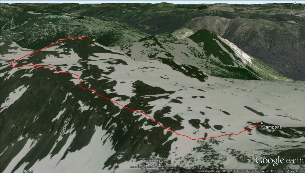
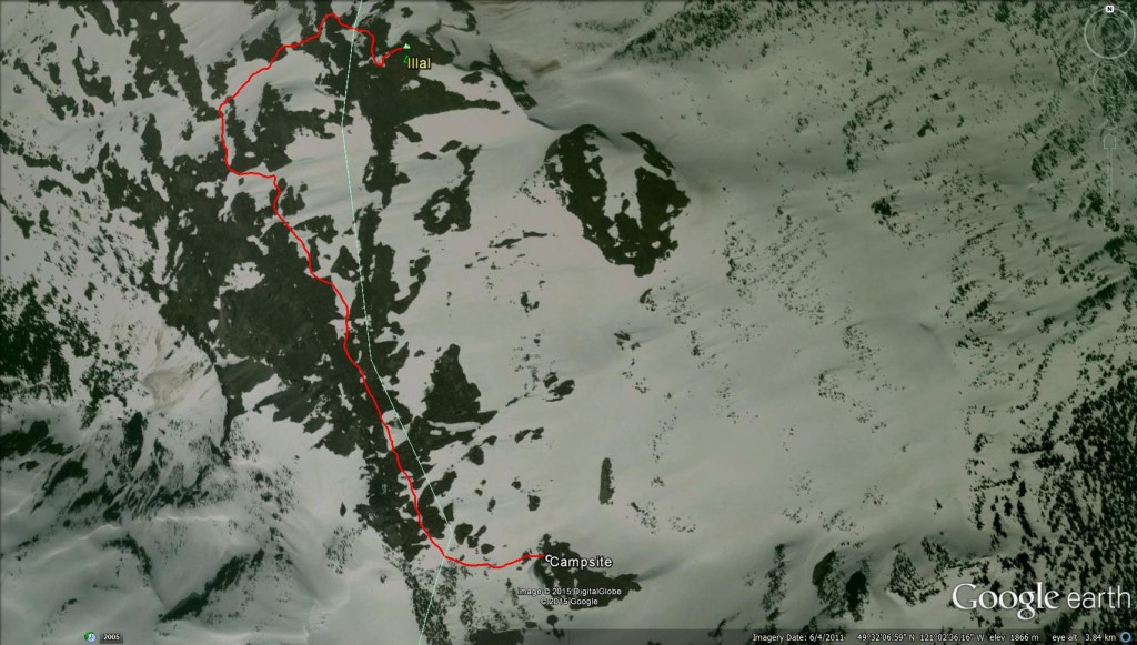
The Hike
We started on the trail around 8am. The first part followed an old, overgrown, flat logging road to the south branch of Illal creek. The creek was an easy rock hop across and we picked up the trail on the other side.
Next, we left the road and continued up a trail which followed a set of switchbacks through some second growth forest. The trail became a little steeper at this point, but very manageable with overnight packs.

The trail flanked around a ridge and lead to a scree slope; there was an obvious bed etched into the scree. The views opened up and revealed nearby mountains, including: Illal Peak and Spiral Peak. They were covered in coats of red and orange alpine foliage.


After the scree slope, we made a left, headed uphill, and soon reached the lower meadows. It’s worth mentioning, you should make note of where you entered the meadows for your hike out, you lose the trail very quickly once you’re in them and it may be hard to find your way back to the right starting point.


We quickly passed through the lower meadows and entered the middle section. Despite the hot and dry summer, we had no issues finding a water source as there were tarns scattered everywhere. We decided to camp slightly higher up, closer to the peaks, and made our way over to the tarn at the base of Jim Kelly peak.


We poked around the area for a little while and found an ideal spot to set up camp. Our site was nestled between a slope and a few trees to stay out of the wind. We set up a bear hang in a big tree, about five minutes downwind from camp.
Once camp was set up, we unloaded the rest of our packs and made our way along the ridge towards Illal Peak. About ten minutes into the hike, it started to hail. Ryan and I exchanged looks and contemplated whether or not we should head back to camp or continue to Illal, assuming the hail will clear up momentarily. Since we were so close, we decided to head back to camp and wait out the weather from the comfort of our sleeping bags and tent.


We hustled back without getting too wet and tucked ourselves in. We waited, and waited, and waited. Over the course of a few hours, the hail turned to heavy rain and heavy rain turned to snow, accompanied by strong winds and thunder. I napped while Ryan rested and occasionally knocked the accumulating snow off of the tent walls and made sure we were still water tight.
When the storm finally stopped, we poked our heads out and caught the last of the sunset. This wasn’t the first time a weather forecast has been incorrect, but going from <1mm of rain to a full blown Winter storm was surprising!


The temperature was much warmer now and we stayed out for dinner and some night photography.


Day 2: Illal Peak
Stats (from Illal Meadows)
The hike to Illal peak is a distinct trail that starts in the meadows. It offers fantastic views of the peaks surrounding the Zopkios Rest Area, looking north, and views of Robbie Reid, Stone Rabbit, and beyond.
- Elevation gain: 170m (tarn at base of Jim Kelly to Illal Peak summit)
- Distance: 1.84km (tarn at base of Jim Kelly to Illal Peak summit)


The Hike
We woke up to blue skies and some accumulated snow.


After breakfast, Ryan and I decided to hike up Illal peak and leave Jim Kelly for a separate trip. The roof of our tent had a decent amount of ice that would melt onto our gear throughout the day – likely because we hadn’t ventilated enough overnight. We left our gear in the tent and decided to pack when we return.
We missed the trail that splits Illal and Jim Kelly/Coquihalla. Instead, we headed directly towards Illal peak through the upper meadows. With no obvious trail, Ryan and I contemplated whether we should approach Illal from the southeast ridge or flank around the western side of Illal, hoping for easier access. We decided to stay on the ridge crest since the western slopes looked promising.


As we explored, we stopped at an outcropping on the ridge that gave an excellent perspective of Coquihalla peak to the SW.


We followed the ridge to the large tarn at the base of Illal Peak. A few old fire rings revealed this was a frequent camp spot. We could see why – the tarn was stunning. We picked up a distinct trail at the NW corner of the lake and followed as it flanked around the western side of Illal through meadowy slopes. Before the trail dropped into the next valley to the north, we swung right and started the steep, but non technical ascent up Illal.


Before the official summit, we stopped for a short break to enjoy views of the next valley over.


Final ascent and summit:


The weather was excellent and we had views far off to the horizon. To the north was the Baldwin Creek valley and the peaks around the Zopkios Rest Area: Yak, Nak, Needle, Flatiron, etc. To the west was Portia and, in the distance, Old Settler, Judge Howay and Robbie Reid. To the south lay Outram, Silvertip, Frosty and, of course, Baker. To the east were the rolling foothills of the Similkameen.


After hanging out for a while on the summit, we headed back to camp. We followed the proper trail and realized where we made our mistake of B-lining to Illal Peak. We should have gone further into the pass between Jim Kelly and the Illal ridge; the trail runs the entire length of the ridge starting from there. The views on the way back were spectacular with more fall colours.


Panoramic view from the top:

We packed up our camp, cooked some lunch, and headed out.
I’m glad we finally got into this area. The Fall colours in Illal meadows were well worth the visit! I’d love to check it out next year during wild flower season.
No huge objectives this long weekend, but it was an eventful two days for sure! There’s a lot of pleasure to be found in taking it easy, not everyone needs to break a personal record every time they leave the house – something I’ve slowly come to realize.
Diabetes Management
I started my weekend with a normal 50% reduced basal rate (during hiking only) and aimed to keep my blood sugars in the 8-12mmol range.
Since I switched to the Animas Vibe insulin pump and integrated Dexcom CGM unit, day trips and overnighters have been incredibly easier in terms of blood sugar management. I’m able to catch any low and high trends and I’m able to observe my blood sugar levels as I change my intensity of hiking throughout the day. This piece of technology truly is magical.
My blood sugar levels were steady during our hike in, a little TOO steady. The CGM unit displays a line graph of my blood sugar readings over 1, 3, 6, 12, and 24 hours. While hiking, I was constantly watching the line and trying to keep it as steady as possible – this means very accurately bolusing any carbs, keeping well hydrated, etc. I was so focused on keeping the line steady, I made some questionable compromises. The 50% reduced basal rate worked for me, I didn’t have any high or low trends during our hike in. To keep that progress steady, I chose not eat as many carbs as I normally would. I was too worried about spiking my blood sugars or ruining the green line display (for those who aren’t familiar with the CGM display, if your blood sugars fall out of range, that section of the line changes to a different colour. Green line = within target). Given Illal meadows is a mellow hike, I think I was ok to not eat as many carbs. If we had chosen a more demanding area, this could potentially be a problem. Are steady blood sugars worth dragging yourself up a mountain due to lack of energy? Normally, no. But on this specific trip, I didn’t even consider my energy levels. All I saw were steady blood sugars and I was ecstatic. That was my first mistake.
My second, unrelated, mistake happened just after the storm blew in. When we decided to hike up Illal peak (before the hail), I was feeling sluggish and ate a pack of PowerBar Gel Blasts. I bolused for half of the carbs (as I usually do) and started hiking towards the peak. When the weather turned and we made a call to head back to camp, I completely forgot about the gels I ate. Before nestling in for a nap, I remembered to turn off my basal reduction, but I forgot to take a full correction for the gels. Needless to say, I woke up with pretty high blood sugars. I suppose I was too excited with all the hail, heavy rain, and snow, and my blood sugar levels slipped my mind. Luckily, I didn’t spike high enough to feel sick or nauseous.
Pack List (+ the Essentials)
- Overnight gear (tent, sleeping bag, thermarest)
- Hiking layers (soft shell pants, wool shirt, tank top, down sweater, rain jacket, light gloves)
- Warmer layers (down jacket, thick wool shirt, wool long johns, toque, mitts)
- Stove + meals
- Camera + Gorilla tripod
- Hiking boots
If you’re interested in exploring more in the area, here are a few other trips we’ve completed off of the Coquihalla Highway:
Thanks for reading!
– Ash
Hi guys. Fantastic trip and an awesome destination. With our third child now it is very hard to go anywhere let alone hiking but we are thinking to buy one of those child backpack carriers and go backpacking with our little one while the other two will be left with relatives. Very inspiring as always so keep it up pls :).
Somebody shared this new trail with me and i thought of sharing it with you guys, maybe you will make your way there before us (that in case if you haven’t been there already):
http://localwhistler.com/news/2015/08/17/skywalk-trail/
And one of Matt’s Gun favorite hikes:
https://www.flickr.com/photos/markostavric/sets/72157648236513361/
This is high on our list. Probably the most beautiful alpine like in BC by far. Cheers!
Vic
Hey Vic, good to hear from you! I read about Skywalk not long ago, we haven’t checked it out yet but it’s on the list.
Those lakes are absolutely stunning! It may be too late to head into the Purcells this year, but it’s high on my to do list next year during larch season, thanks so much for the link!
Hope you’re doing well. – Ash