Ashika Morasiewicz
Outdoor Adventurer from the North Shore, BC
Hike the Four Cascades Loop, Burke Mountain, Coquitlam, BC
Trip date: April 2, 2017
Spring gives us the unique chance to participate in winter and summer activities at the same time; if we feel like skiing or snow-camping, we can, and if we feel like avoiding the snow and indulging in some greenery, we can. When the weather starts to warm things up, the valley floor is the first thing to clear and local waterfalls usually start working their magic, tempting us to leave the snow behind. The Four Cascades Loop (from Lyle Litzenberger’s Burke and Widgeon – A Hiker’s Guide) gave us what we were looking for. We completed a loop of four waterfalls involving Harper Road, The Coquitlam Lake View Trail, the Sawblade Bike Trail, and Woodland Walk Trail. We completed the loop in a counter-clockwise direction; for a more demanding hike with steeper uphill terrain, you can complete it in a clockwise direction.
The Four Cascades in order:
- Coho Creek’s Dry Crossing
- Sawblade Falls
- Woodland Walk Falls
- Pritchett Creek
Stats
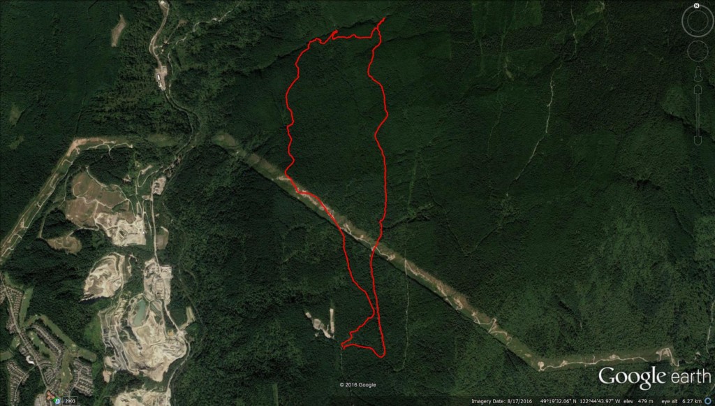
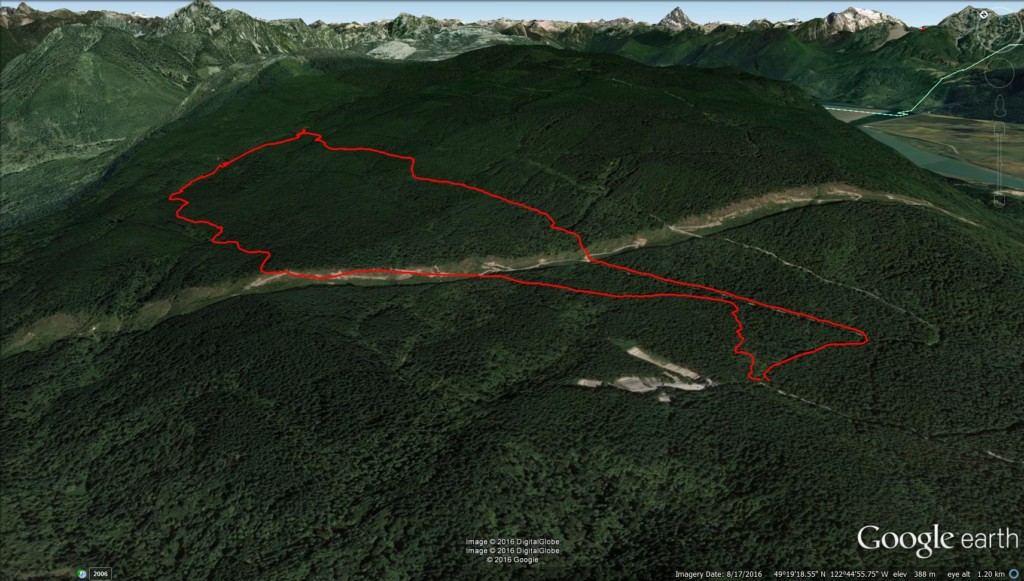
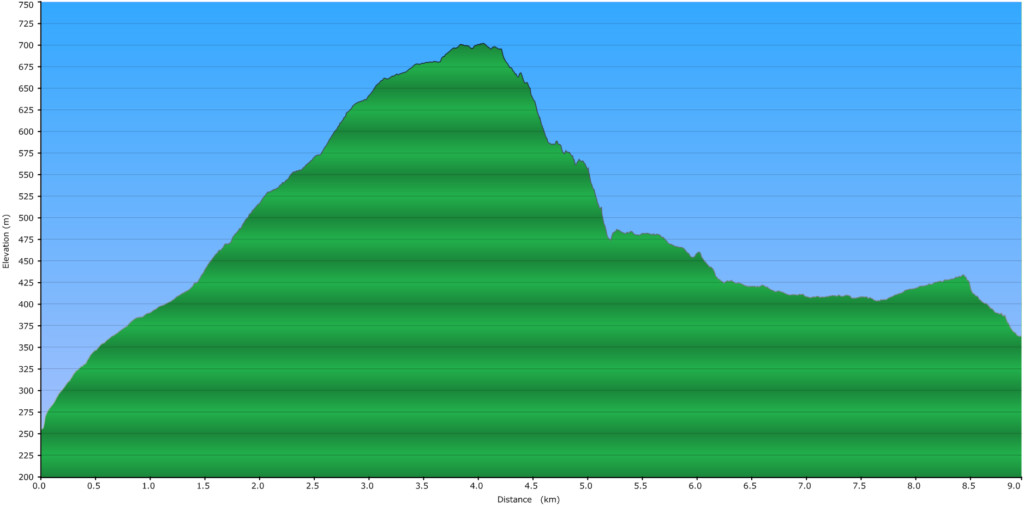
Google Earth & Elevation Profiles
")
")

Access
Directions from Vancouver (click on the image below for Google Map directions):
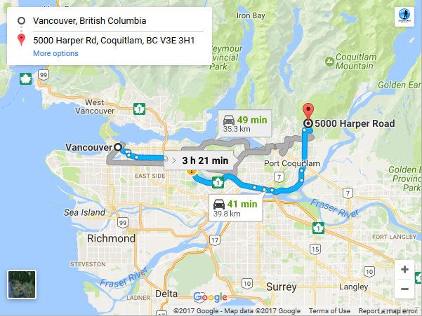
- Head east on Hwy 1 towards Coquitlam for ~22km.
- Take exit 44 United Blvd and continue on the Maryhill Bypass.
- Turn left on to Broadway street.
- Continue on to the Coast Meridian Overpass, then continue straight for ~5km.
- Turn right on Harper road and continue for ~2km.
- Park at the last yellow gate before the Gun Club.
The Hike
Ryan & I parked close to the Harper Road gate, closest to the Gun Club. We walked up Harper road and turned left at the first road junction. Shortly after, we stayed on the road at the signed junction (left for Woodland Walk, straight for Coquitlam Lake View Trail (CVLT)). We continued under the powerlines to a second junction where the CLVT and South Slope trail continued straight, slightly uphill.
 Signs Along the Coquitlam Lake View Trail")

We ignored all the bike trails (mostly to our left) and continued on the main trail to the next junction. We had the option of continuing left/straight for Sawblade Falls or right for the CLVT. We turned right for our first cascade of the day, Dry Crossing Falls, which is along the CLVT. The signed junction was a little obscure with faded signs and blowdown. We nailed the sign for Sawblade Falls back on to a tree where it is easier to see.


The trail followed slightly uphill before leveling out again. Along the trail we found remnants of large trees that were once logged.

Snow was a more steady at this point. As we got closer to the falls, we heard the roar of Coho Creek. Ryan and I rock hopped across the ‘dry’ crossing and Skeena skeptically swam through (sorry, no pictures of her, though I agree they would have been awesome).
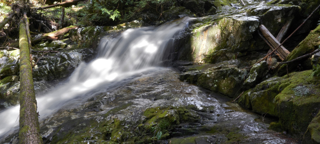
Cascade #1, Dry Crossing Falls:


After a short break at the first cascade, we backtracked to pick up the Sawblade bike trail. I took a quick look at the CLVT which continued, snow looked fairly steady from where we were. The GPS and Lyle’s waypoints came in handy at this point. There was quite a bit of snow here and we missed any obvious start to the bike trail. We continued downhill and started traversing left when we picked up an old spur road in the trees. We noticed we were headed in the wrong direction and decided to head downhill.


When the snow diminished, we picked up the Sawblade bike trail and followed it down. The bike trail eventually joined up with an old road where we followed signs to Sawblade Falls.


Cascade #2, Sawblade Falls:

From Sawblade Falls, we continued downhill on a well marked and well signed trail.


We stopped at the Coquitlam Lake/Eagle Mountain viewpoint to take in the views.

The trail then descended steeply down to the Woodland Walk Falls. We ignored the lower CLVT trail fork and continued down to Woodland Falls. This area was also signed and flagged.
Cascade #3, Woodland Walk Falls:

From the Woodland Walk Falls, we followed the lower loop along the Woodland Walk to the last cascade, Pritchett Creek. Most of the trail was easy to follow with a very gentle grade through the trees. The last cascade was not as impressive as the first three, but it was on the way back and worth a quick stop at the bridge.
Cascade #4, Pritchett Falls:

We continued on the road under the powerlines to where the Woodland Walk trail branched off to the right. From the Woodland Walk, we connected to the Garbage bike trail (to our right), and took the bike trail back down to Harper gate.
Favourite shots of Skeena throughout the day:


My favourite falls in order were Sawblade Falls, Dry Crossing Falls, Woodland Walk Falls, and Pritchett Falls. The Lower Burke trails are a favourite this time of year with the various cascades and snowfree slopes. I highly recommend checking out Lyle’s book for full details on the different loops you can hike on Burke Mountain.
Diabetes Management
My blood sugar levels were at bay throughout the day. The hike wasn’t overly demanding so I didn’t have any lows or spikes. I fueled myself with Welches fruit snacks and stayed hydrated.
Pack List
The 10(+6) Essentials
1.5L of water
Snacks
Day pack
Hiking boots
Warm layers
Camera
– Ash